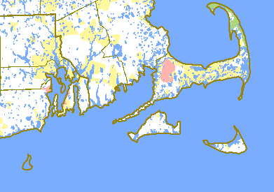
The island of Martha's Vineyard, situated five miles from the mainland, south of the " Heel of the Cape," lies between 70° 27' 24" (Cape Poge light) and 70° 50' (Gay Head light) west longitude, and between 41° 18' 04" and 41° 28' 50" (West Chop light) north latitude. Its longest measurement east and west is about nineteen and one-fourth miles, and its greatest width from north to south is nine and three-eighths miles, in which is comprised about one hundred square miles, or about sixty-four thousand acres of land. With the Elizabeth Islands (Gosnold) and Noman's Land it constitutes the county of Dukes County, the last two having about seven thousand acres of superficial area, making a total of about seventy-one thousand acres of actual extent in the entire county.
[Dukes County, including Gosnold according to our State Census, the only one giving opportunity for comparison, contains 33,645 acres of farming lands, in 371 farms; having 4,893 acres of cultivated land, appraised at $30.12 per acre; 18,000 acres of pasture or unimproved land at $9.34; 9,200 acres of woodland at $12.42, and 1,858 acres of unimprovable at $1.43 per acre. (Report of Mass. Board of Agriculture, 1883.)
