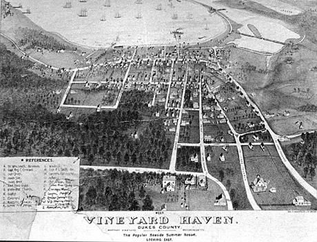


Caption: "Vineyard Haven / Dukes County / Martha's Vineyard / Massachusetts / The Popular Seaside Summer Resort / Looking East"
Signs: References / A. William Leach Residence / B. Capt. Benj. C. Cromwell / C. Capt. Clough / D. Beach Side / E. Lane's Block / F. East Chop Light / G. Methodist Church / H. Baptist Church / I. Episcopal Church / J. Mansion House / K. Grove Hill House...*
* ... "L. Windmill / M. Capt. P. L. Smith Res. / N. Crocker Harness Fac. / O. A...[?] / P. Capt. Owen Res. / Q. Sailors Free Reading Room / R. Eldridge's Wharf / S. Lagoon Heights / T. Crocker Summer Villa[?] / U. U.S. Marine Hospital / V. Hines Cottage / A. Association Hall
Can you identify any people, things, places, or events in this photograph? How about the time period? Or do you know where this photo came from? Email me at cbaer@vineyard.net.
Date: before 1900?
Location: Vineyard Haven - downtown -
People: Leach, William, Dr.; Cromwell, Benjamin C., Capt.; Clough, Capt.; Smith, P. L., Capt.; Owen, Capt.; Eldridge, _____; Crocker, _____
Keywords: maps; illustrations; views; harbors; bridges; Lagoon; Hines Point; Main Street; Forest Ave.; Spring St.; Franklin St.; Grove Ave.; Williams St.; Drummer Lane; Union Wharf